Products
Reports

NYC Climate Vulnerability, Impact, and Adaptation Analysis (VIA)
This report assesses future climate change and its potential impacts, to inform decision-making by the City of New York. The findings draw from an 18-month study conducted by an interdisciplinary team of researchers led by Professors Joel Towers and Dr. Timon McPhearson at The New School’s Tishman Environment and Design Center and Urban Systems Lab commissioned by the NYC Mayor’s Office of Climate & Environmental Justice (MOCEJ) through a Town+Gown partnership program.

The Summary For Urban Policymakers of the IPCC’s Sixth Assessment Report
The Summary for Urban Policymakers (SUP) series provides an overview of the IPCC Assessment Report (AR6), which USL’s Timon McPhearson was a lead author on. This SUP report was released during COP27 in Egypt, providing targeted summaries of science on what the impacts from climate change, adaptation and vulnerability mean for cities and urban areas.

NYC Climate Adaptation Scenarios for 2100
In the face of global climate change, city governments must anticipate and guide decisions in response to extreme weather-related events, including coastal and inland flooding, heat waves, multi-hazard risks, drought, and winter extremes. With the goal of addressing this challenge, between Sept. 24 - Oct. 22, 2021, the National Science Foundation (NSF) Social-Ecological-Technological Systems (SETS) Convergence Research Network partnered with the New York City (NYC) Mayor’s Office of Climate and Environmental Justice (MOCEJ) to facilitate the NYC Climate Adaptation Scenarios workshop series, a wide ranging yet structured set of anticipatory discussions on future climate resilience and adaptation. Through a series of five 3-hour virtual workshops, diverse participants co-developed positive future visions for New York City of sustainability, resilience, and adaptation to climate change and extreme events.

Biodivercities By 2030: Transforming Cities’ Relationship With Nature
A report from the World Economic Forum's Global Commission on BiodiverCities, a high-level commission of 30+ world-renowned experts and practitioners to synthesize the latest research with practical solutions in the service of sustainable, inclusive and nature-positive urban development. With contributions from USL Director Timon McPhearson.
Data Visualization Products
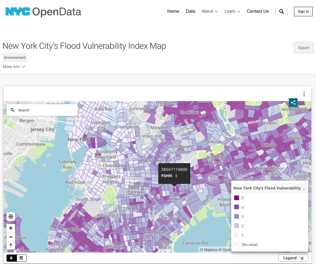
NYC Flood Vulnerability Index (FVI)
The NYC Flood Vulnerability Index (FVI) assesses the distribution of vulnerability to flooding across NYC in order to guide flood resilience policies and programs. Vulnerability contains three components: exposure to a hazard, susceptibility to harm from the exposure, and capacity to recover. There are six hazard-specific FVIs, one for each of the six different flood hazard scenarios, which include current and two future storm surge scenarios and current and two future tidal flooding scenarios. Exposures vary for different types of flooding and different scenarios within each flood type.

Ocellus
Ocellus is the USL’s Data Visualization Platform, an interactive web application that visualizes Social, Ecological, and Technological Systems (SETS) data. The platform was designed and implemented initially for nine different cities within the Urban Resilience to Weather-related Extremes (UREx) Sustainability Research Network. It was conceived as a tool to produce knowledge, bridging the gap between quantitative social, ecological and infrastructure data, and the rich and layered qualitative insights compiled at local stakeholder future visioning workshops.

Ocellus XR
Ocellus XR is a mixed reality application that leverages the Urban Systems Lab’s Data Visualization Platform to present users with unique interactive geospatial maps of heat, flood risk and other climate indicators in New York City.

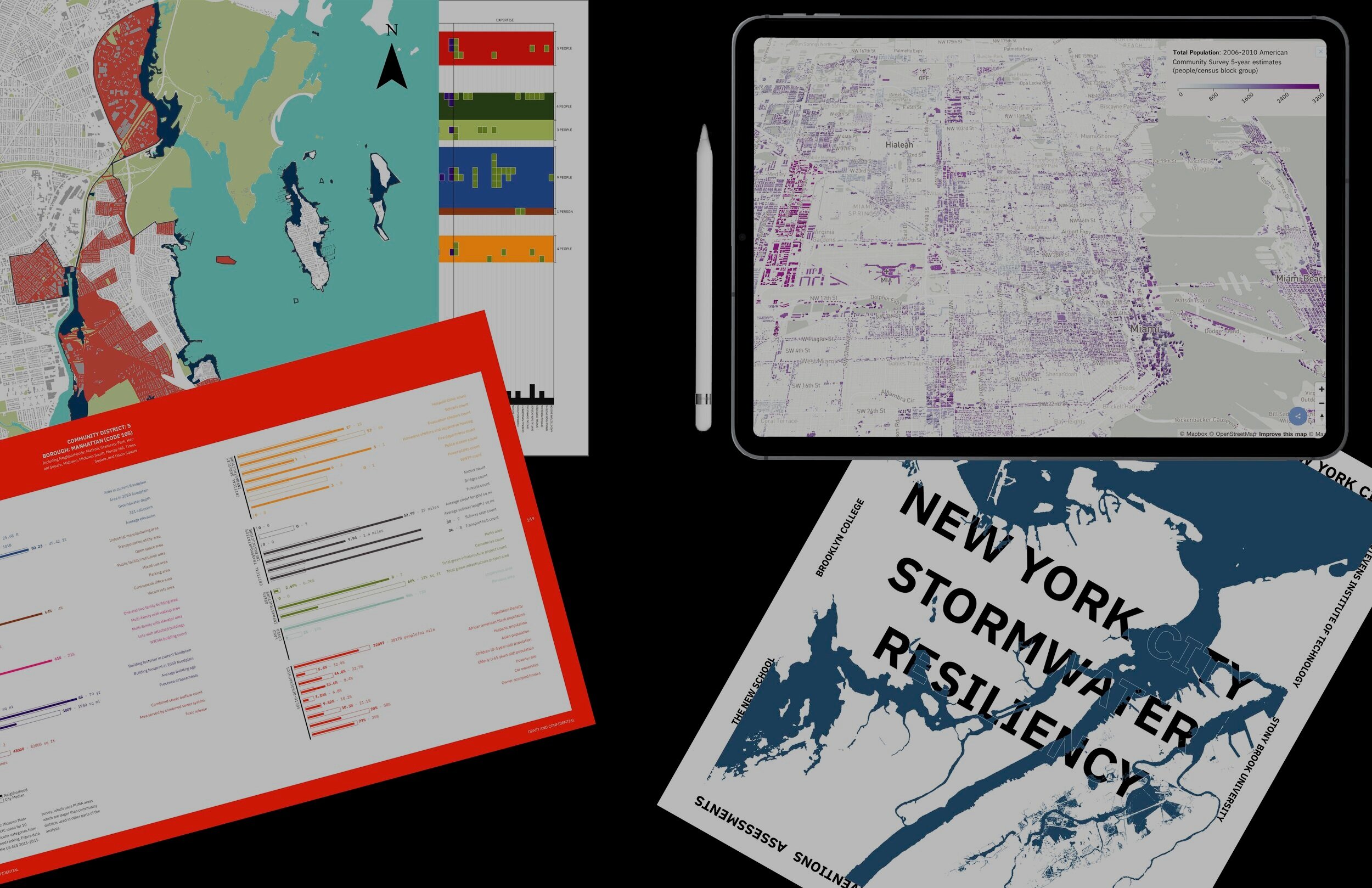
Stormwater.nyc
Stormwater.nyc is a data visualization mapping platform that integrates publically available data on stormwater resiliency in NYC, with population demographics, land use/cover data layers, location of critical infrastructure and greenspaces, and the New York Panel on Climate Change’s floodplain maps. To date, no other mapping platform has been developed that provides the ability to compare and contrast the potential social and infrastructural risk of future flooding scenarios in NYC. Over 2021, our data visualization team improved the functionality of the platform to allow toggling between data layers to better interact with the scenarios and social and infrastructural information. The aim is to provide a multi-hazard risk decision-support tool to improve resiliency prioritization and to create a central node for considering the interdependent and cascading risks that multiple climate hazards and threats have on NYC’s diverse communities.

Greening From the Rooftops
A user interface for mapping the green roof potential of NYC developed by former RA Nour Zein. Green roofs are a proven solution to the urban consequences of climate change. Where are the current green roofs located, and how does the potential for green roofs look like in NYC? What ecological impacts would green roofs have?
Maps, Games and Print Materials

Ekos: The Path to Resilience
Ekos: The Path to Resilience is a multiplayer board game that challenges a group of six community members — a Mayor, City Planner, Community Organizer, Ecologist, Designer, and Modeler — to come together and envision a more equitable and sustainable Ekos in the face of climate change and other challenges. During the game of Ekos, players alternate between building SETS and responding to moderate and extreme events. Working cooperatively to challenges earns you Sustainability, Equity, and Resilience points. Ekos was developed with the goal of creating a playful platform for individuals and communities to discuss and learn about issues of urban resilience, climate governance, and community based codesign.

Climate Ready Uptown Plan
The Climate Ready Uptown Plan (CRUP) is a physical pamphlet that helps Northern Manhattan community members understand their individual risk to climate related disasters – specifically extreme heat, coastal and stormwater (pulluvial) flooding – and provides pertinent information to help prepare themselves and their families. Designed by WE ACT for Environmental Justice in partnership with East Harlem COAD, Harlem Emergency Network and Urban Systems Lab, the Plan is tailored to residents of Northern Manhattan to better understand their flood risk. From the onset, CRUP was designed with community at the forefront. WE ACT’s Climate Justice Working Group helped with the initial planning, research and layout of the tool, and scenario planning meetings as well as focus groups with Northern Manhattan residents helped WE ACT refine the messaging and language included in the plan to make it as effective and relatable as possible.
Web Resources & Storymaps

Milwaukee Flood Health Vulnerability Assessment
A storymap to accompany the Milwaukee Flood Health Vulnerability Assessment report. Co-developed by Lawrence Hoffman at Groundwork USA.

Is Green Infrastructure a Universal Good?
Researchers from Cary Institute of Ecosystem Studies and Urban Systems Lab analyzed 122 green infrastructure plans from 20 US cities to reveal how urban planning has contributed to current landscapes of inequality, and what avenues exist to transform planning for equitable infrastructure. To present findings from the study, the USL developed GIequity.org, a new website identifying current approaches, gaps, and necessary transformations in urban green infrastructure planning. The website includes an in-depth look at each city studied, including green infrastructure history, a snapshot of key findings, maps, a GI equity score, and targeted recommendations for stakeholders, community groups, policymakers and planners, as well as foundations and funders.

Urban Flooding, Equity, and Green Infrastructure: Syracuse as Case Study
The USL has continued to leverage the suite of tools offered by ESRI’s ArcGIS program, including Stormaps or narrative driven web projects that integrate data and storytelling. For the Kresge support Environmental Justice of Urban Flood Risk project, the team developed a new storymap “Urban Flooding, Equity, and Green Infrastructure: Syracuse as Case Study”. The storymap explores the ambitious GI program that Onondaga County has successfully implemented targeting the city’s water quality problems related to the Combined Sewer Overflows (CSO) caused by its Combined Sewer System.