Planning Resilience Together – Collaborative Climate Solutions in Southwest Yonkers
RESEARCH SUMMARY
By Emma Holtzman
As a community educator whose work spans health equity, environmental justice, sustainable agriculture, and urban policy, Emma is thrilled to be the Public Engagement Fellow with the Urban Systems Lab and work with teams researching urban ecological systems. Emma is grateful to continue work at the intersection of her many interests, building urban resiliency for all communities and the environment. With a background in food systems, zero waste and urban circularity, and co-creating equitable access to green space and gardens, Emma is eager to assist USL in their research and communications.

KEY TAKEAWAYS
The Southwest Yonkers Green Infrastructure Feasibility Study represents a successful boundary-crossing collaboration between community expertise and scientific research.
The initiative prioritized technical feasibility for community benefit, focusing on areas where green infrastructure could reduce flooding while providing multiple ecosystem services that align with resident priorities.
This community-centered approach to green infrastructure planning serves as a model for environmental justice interventions by addressing climate adaptation needs in historically underserved neighborhoods like Nodine Hill and Getty Square.
In Southwest Yonkers, where storm drains routinely overflow and residents brace for every heavy rain, a unique partnership is offering a new way forward. The recently completed Southwest Yonkers Green Infrastructure Feasibility Study (PDF), a collaboration between Groundwork Hudson Valley and the Urban Systems Lab (USL), is more than just a technical report – it’s a model for how science and community knowledge can come together to foster local adaptation and equity in the face of climate change.

Southwest Yonkers Green Infrastructure Feasibility Study, Prepared by Groundwork Hudson Valley and Anna Kramer, Urban Systems Lab.
Science + Community: A Boundary-Crossing Collaboration
At its core, this initiative exemplifies what scholars call “boundary work” – the practice of crossing institutional lines between science, policy, and community organizing to co-create usable knowledge (see Bednarek, A.T., Wyborn, C., Cvitanovic, C. et al. (2018). Boundary spanning at the science–policy interface: the practitioners' perspectives. Sustainability Science, 13(4), 1175-1183). Groundwork Hudson Valley.org/, a trusted, long-standing environmental justice nonprofit, brought a deep local context and relationships. The Urban Systems Lab, where I serve as a research fellow, contributed geospatial risk modeling, environmental planning tools, and scientific rigor.
Together, we asked:
Where precisely is flooding happening now, and how will it change in the future?
What kinds of green infrastructure (GI) make the most sense in this urban terrain?
Who will benefit from future infrastructure decisions and who has been left behind by past infrastructure decisions?

Land Surface Temperature and Impervious Surface increase as Home Owners’ Loan Corporation (HOLC) neighborhood grade decreases, while Tree Canopy Cover increases with neighborhood grade. Source: Groundwork Hudson Valley Climate Smart Neighborhoods Storymap.
https://www.groundworkhv.org/wp-content/uploads/2024/06/Yonkers-Factsheet-Final-2.pdf
A Method with People at the Center
The methodology was both systematic and rooted in lived reality. In a recent webinar hosted by Groundwork Hudson Valley, Anna Kramer from the Urban Systems Lab presented methodologies and findings from the Southwest Yonkers Green Infrastructure Feasibility Study, completed in January 2025. The USL team started by identifying key ecosystem services – the measurable benefits that green infrastructure delivers for community health, economic resilience, and environmental quality – then, worked with stakeholders to prioritize those services based on community goals.
Next, USL built a framework to evaluate different GI strategies – including, bioswales, rain gardens, porous pavement – based not only on technical feasibility, but on how well they aligned with priorities like water quality, flood risk, aesthetics, and educational potential.

A Closer Look at Green Infrastructure for Urban Flooding, Presented by Anna Kramer, Urban Systems Lab (USL) during The Tree Talk: The Flooding Stops Here webinar, hosted by Groundwork Hudson Valley.
Then came the mapping! Using LIDAR and flood model data, the USL team identified ten priority sewersheds, micro-drainage areas where GI could reduce flood depth and impact. At every step, the question wasn’t just “what works,” but “what works for this place and for these people?”
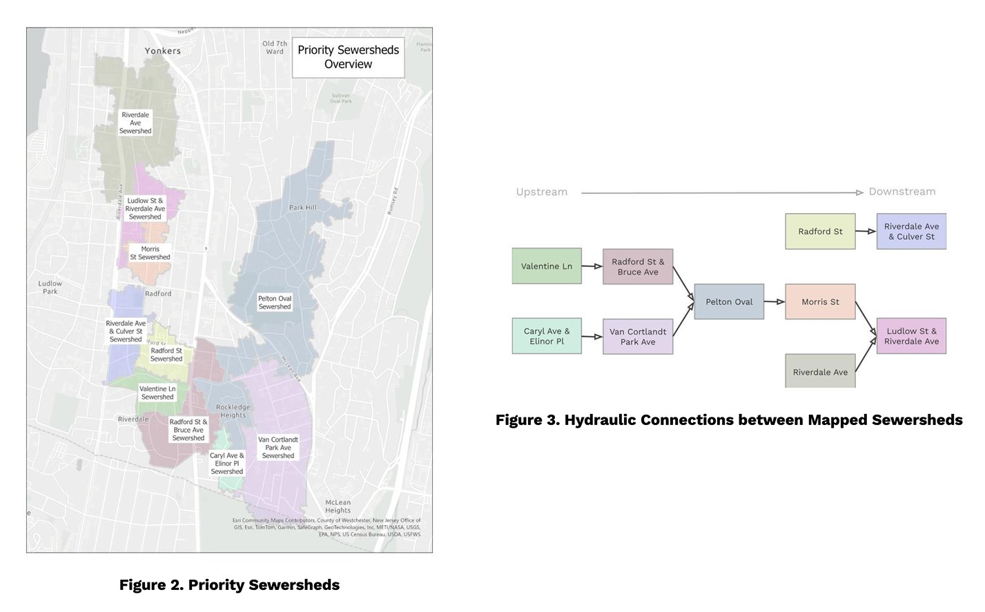
Figure 2: Priority Sewersheds Overview from the Southwest Yonkers Green Infrastructure Feasibility Study, mapped using high-resolution LIDAR data. Prepared by Groundwork Hudson Valley in collaboration with Anna Kramer, Urban Systems Lab.
Figure 3: Hydraulic connections between mapped sewersheds. Please use the following caption for that: Mapped sewershed connections in Southwest Yonkers, illustrating drainage patterns and interlinked micro-watersheds identified for targeted green infrastructure interventions. From the Southwest Yonkers Green Infrastructure Feasibility Study, prepared by Groundwork Hudson Valley and Anna Kramer, USL.
Community-First Infrastructure Planning
A critical innovation in this study is the Green Infrastructure toolkit’s emphasis on community benefit and stewardship. The toolkit positions GI as more than a set of physical interventions: GI becomes a platform for engagement. From public bioswales that double as educational spaces to participatory stewardship models, the recommendations aim to return agency to residents, not just manage runoff.
This is especially important in Southwest Yonkers, where neighborhoods like Nodine Hill and Getty Square bear the brunt of environmental neglect and disinvestment. By asking how green infrastructure can be done with and for neighborhoods, the urban plan is co-produced, offering a future vision for an adapted neighborhood fitted with the needs and wants of the local community.
This initiative underscores the power of interdisciplinary, community-engaged planning. It’s a model for how green infrastructure can be more than a stormwater solution – it can be a catalyst for environmental justice, climate adaptation, and public trust.
To dive into the full report and maps, view the Southwest Yonkers GI Feasibility Study and an additional Fact Sheet (PDF) about the environmental justice of urban flood risk and green infrastructure solutions.
For a more in-depth understanding, view the full webinar recording here (58 minutes).
Edited by Valérie Lechêne
