Resilience Science Must-Knows
This report distills decades of resilience science into nine clear, actionable Must-Knows that equip decision-makers across sectors and scales with a shared, science-based foundation to cope, adapt, and transform in the face of ongoing uncertainty.
Read More
AI for a Planet Under Pressure
This report examines both the promise and limits of using AI as a research method across eight key sustainability challenge areas, from interconnected climate shocks and Earth system complexity to urban resilience, freshwater security, and collective decision-making under planetary pressure.
Read More
NATURA Global Roadmap for Urban Nature-based Solutions
A global assessment of research and practice that charts a path for scaling nature-based solutions (NbS) to make cities more resilient, equitable, and sustainable.
Read More
PNAS: Nature-based Solutions for Urban Sustainability
The Nature-based Solutions for Urban Sustainability Special Feature highlights the role of nature-based solutions (NBS) in addressing the complex challenges of urban resilience and sustainability amid climate change.
Read More
ClimateIQ
ClimateIQ is an AI driven, multi-hazard risk and vulnerability tool leveraging Machine Learning, Big Data, and multiple climate hazard model environments to reveal high resolution hotspots of overlapping climate risks in cities and urbanized regions.
Read More
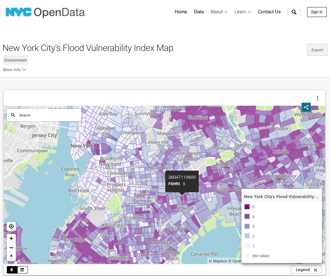
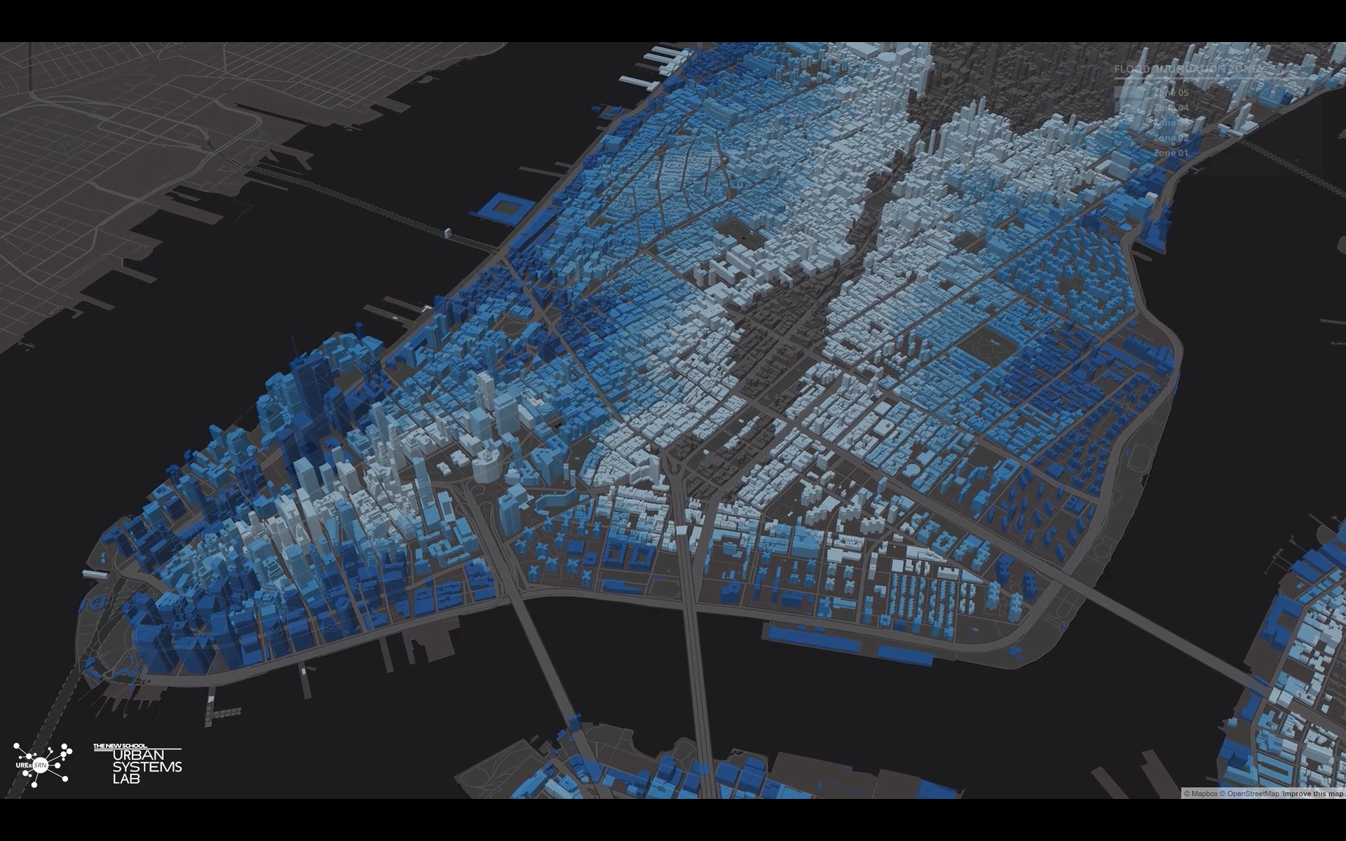
NYC Flood Vulnerability Index (FVI)
The NYC Flood Vulnerability Index (FVI) assesses the distribution of vulnerability to flooding across NYC in order to guide flood resilience policies and programs. Vulnerability contains three components: exposure to a hazard, susceptibility to harm from the exposure, and capacity to recover.
Read More
GIequity.org
GIequity.org is a platform developed by the Urban Systems Lab to share findings from a study of 122 green infrastructure plans across 20 U.S. cities, highlighting inequities in planning and offering insights, data, and tools to support more just and effective green infrastructure strategies.
Read More
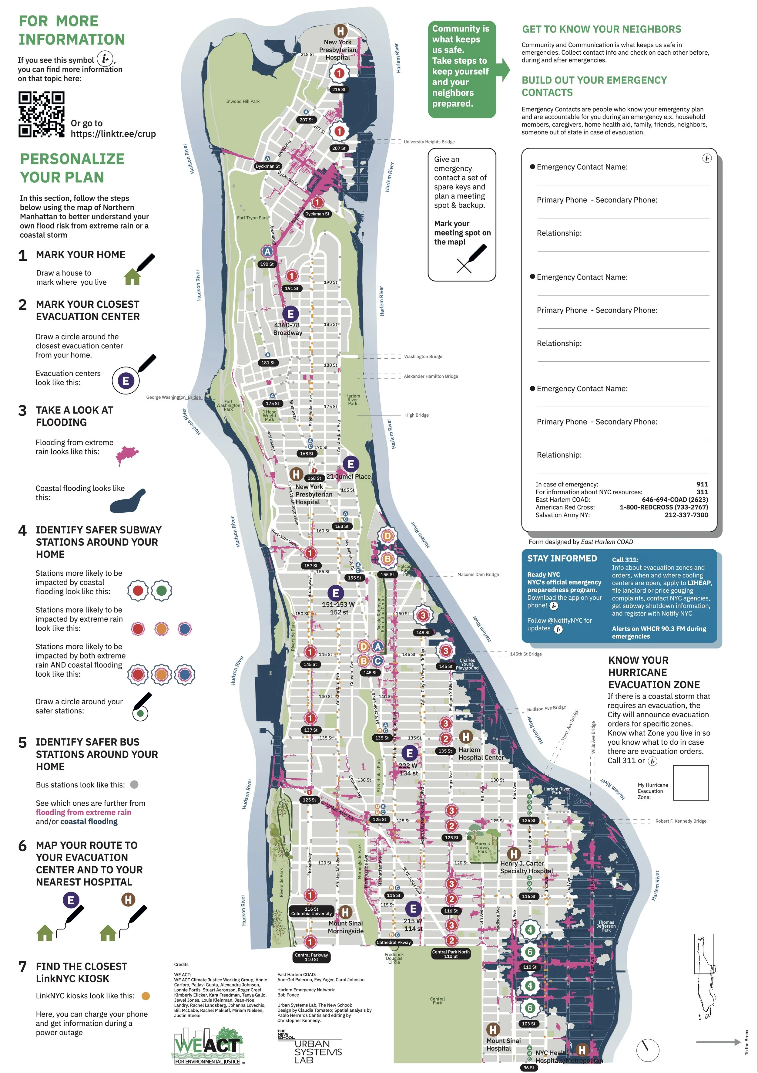
Climate Ready Uptown Plan
The Climate Ready Uptown Plan (CRUP) is a guide and map to help Northern Manhattan community members understand their individual risk to climate related disasters
Read More
Adapting to Multiple and Cascading Climate Change Hazards and Risks
A report developed by researchers at the Urban Systems Lab, Cornell University and others, in partnership with RISE and Universe City exploring strategies for adapting to multiple, compounding climate hazards in New York City.
Read More
Milwaukee Flood Health Vulnerability Assessment
The Milwaukee Flood and Health Vulnerability Assessment (FHVA) is an assessment tool which identifies communities across Milwaukee where exposure to urban flooding and pre-existing health, housing and socioeconomic conditions intersect and create disproportionate vulnerabilities to the impacts caused by extreme flooding.
Read More
Modeling Stormwater Flooding in Proctor Creek & the Atlanta University Center
A flood hazard exposure study focused on the Proctor Creek watershed—an area historically impacted by pluvial flooding.
Read More
Southwest Yonkers Green Infrastructure Feasibility Study
This report evaluates a green infrastructure (GI) network to reduce combined sewer overflows, urban flooding, and climate risks in Southwest Yonkers. Using hydrologic modeling and ecosystem service prioritization, it proposes targeted GI solutions for a 52-acre sewershed along Riverdale Avenue.
Read More
Flood Risk Modeling in the Saw Mill River Watershed
The Saw Mill River Watershed Flood Vulnerability Modeling Project, led by the Saw Mill River Coalition and supported by the Urban Systems Lab, assesses climate-driven flood risks and provides tools for long-term land-use planning. The project supports equitable resilience by integrating flood modeling with habitat restoration, public access, and environmental justice goals.
Read More
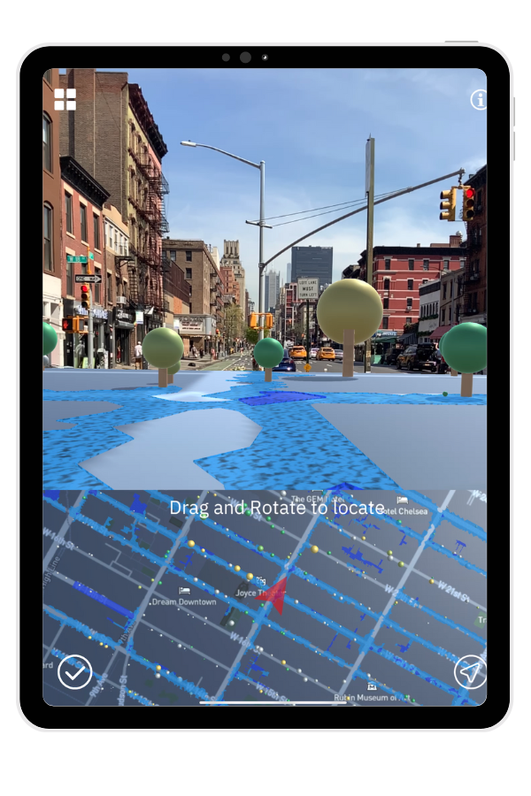
OcellusXR
Ocellus XR is a mixed reality application that leverages the Urban Systems Lab’s Data Visualization Platform to present users with unique interactive geospatial maps of heat, flood risk and other climate indicators in New York City.
Read More
Urban Flooding, Equity, and Green Infrastructure: Syracuse as Case Study
Urban Flooding, Equity, and Green Infrastructure: Syracuse as Case Study is a storymap developed to explore Onondaga County’s ambitious green infrastructure (GI) program, which addresses water quality issues caused by Combined Sewer Overflows (CSOs) in Syracuse’s Combined Sewer System, while also highlighting equity considerations in flood risk reduction.
Read More
Stormwater.NYC
Stormwater.nyc is a mapping platform that visualizes NYC stormwater resiliency by integrating public data on demographics, land use, critical infrastructure, green spaces, and floodplains from the New York Panel on Climate Change.
Read More
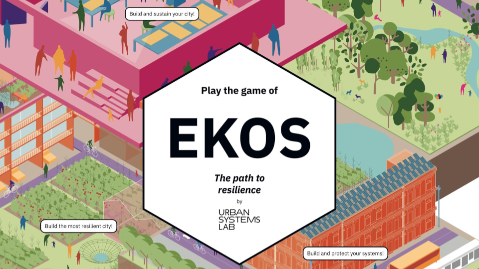
Ekos: The Path to Resilience
Ekos is a multiplayer board game that uses systems thinking and strategy to explore concept of urban resilience and nature-based solutions.
Read More
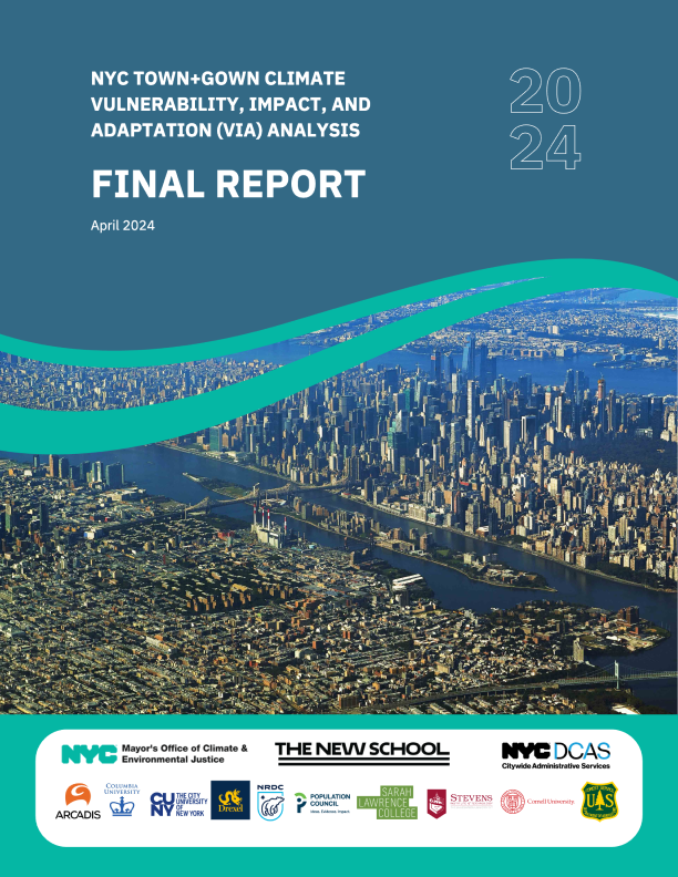
NYC Climate Vulnerability, Impact, and Adaptation Analysis (VIA) Final Report
This report assesses future climate change and its potential impacts, to inform decision-making by the City of New York.
Read More
Ocellus
An interactive web application that visualizes Social, Ecological, and Technological Systems (SETS) data.
Read More
Biodivercities By 2030: Transforming Cities’ Relationship With Nature
A report from the World Economic Forum's Global Commission on BiodiverCities to synthesize the latest research with practical solutions in the service of sustainable, inclusive and nature-positive urban development.
Read More