Posts in Urban Climate Resilience
ClimateIQ

ClimateIQ is an AI driven, multi-hazard risk and vulnerability tool leveraging Machine Learning, Big Data, and multiple climate hazard model environments to reveal high resolution hotspots of overlapping climate risks in cities and urbanized regions.

The tool will especially serve agencies, institutions, cities and town planners, and low-income, minority, immigrant and informal communities looking for local climate risk data to prioritize interventions, create resilience adaptation plans, and to plan and prepare for emergency response to coastal flooding, extreme rainfall, drought, air quality, and heatwaves.

ClimateIQ will enable communities to improve risk planning, management and protection through an open access and intuitive digital dashboard to allow cities and communities to understand current, near term and future risk exposure, and to advance effective risk reduction, adaptation, and emergency management.

The ClimateIQ team brings extensive experience in climate risk modeling, AI applications, data analysis and visualization, as well as working with diverse stakeholders in cities. Led by Dr. Timon McPhearson, Director of the Urban Systems Lab (USL) at the New School in New York City, the core team includes faculty and researchers at The New School, along with partners at Climasens, Stockholm Resilience Centre (SRC), Beijer Institute of Ecological Economics, Cary Institute of Ecosystem Studies and George Mason University. Support provided in part by Google.org Impact Challenge on Climate Innovation.

Milwaukee Flood Health Vulnerability Assessment

The Milwaukee Flood and Health Vulnerability Assessment (FHVA) is a collaborative effort between Groundwork Milwaukee and The New School’s Urban Systems Lab to develop an assessment tool which identifies communities across Milwaukee where exposure to urban flooding and pre-existing health, housing and socioeconomic conditions intersect and create disproportionate vulnerabilities to the impacts caused by extreme flooding. The aim of the project is to provide critical information on both flood exposure and social vulnerability to support community-based advocacy and future planning to mitigate potential flood and health risks. 

Link to Storymap

Link to Report (PDF)

Milwaukee Flood and Health Vulnerability Assessment Storymap

Environmental Justice of Urban Flood Risk and Green Infrastructure Solutions
ezgif.com-gif-maker.gif

Project Team: Pablo Herreros, Elizabeth Cook, Timon McPhearson, Claudia Tomateo

The Environmental Justice of Urban Flood Risk and Green Infrastructure Solutions project aims to better understand the environmental justice impacts of climate change related flooding on minority and low-income communities and assess social equity in green infrastructure planning for reducing urban flood risks. Through data visualization and modeling future flood risk, the project will address two central questions concerning flood risk, and green infrastructure development: (1) Who is more exposed to flooding? And (2) who benefits most by current green infrastructure plans or developments?

Learn More

Interdependent social vulnerability of COVID-19 and weather-related hazards in New York City

Project Team: Timon McPhearson, Luis Ortiz, Ahmed Mustafa, Chris Kennedy, Claudia Tomateo, Daniel Sauter, Z. Grabowski, Pablo Herreros-Cantis, Veronica Olivotto

NSF_rapid2-04-01.jpg

The USL’s Covid-19 related research aims to integrate survey, social media, building infrastructure, energy demand and use, and social-demographic data with simulations of potential emerging weather-related extremes to examine interdependent social vulnerability to COVID-19 and weather in New York City (NYC).

Learn More

New York City Stormwater Resiliency
timon-mcphearson.jpg

Project Team: Timon McPhearson, Daniel Sauter, Claudia Tomateo, Elizabeth Cook, Veronica Olivotto

The NYC Stormwater Resiliency Study was a joint effort with New York City governmental stakeholders, including the Department of Environmental Protection (DEP), Mayor’s Office of Resiliency (MOR), and Emergency Management (NYCEM). The aim was to improve service reliability and resiliency of stormwater systems by planning and implementing effective and viable green infrastructure strategies across the city through integrated stormwater management.


Project Updates

In May 2021, the NYC Mayor's Office released the first ever citywide Stormwater Resiliency Plan, which includes an analysis of flooding caused by extreme rainfall events across the 5 boroughs. The Plan draws from results of the NYC Stormwater Resiliency Study, a Town and Gown initiative co-led by the Department of Environmental Protection (DEP), Mayor’s Office of Resiliency (MOR), Emergency Management (NYCEM), and several academic partners including the Urban Systems Lab (USL) at The New School. The overall goal of the study was to develop a unique model to advance the City's assessment of present and future exposure to urban flooding, to use these data to identify the most at-risk parts of NYC, and to identify interventions to offset this exposure. The USL co-led the development of a hydrologic model of flooding, and simulation of citywide flood exposure for twenty current and future storm scenarios with partners at Brooklyn College.

However, what is not clear is how future flooding in NYC may disproportionately impact critical infrastructure and minority and low income populations.

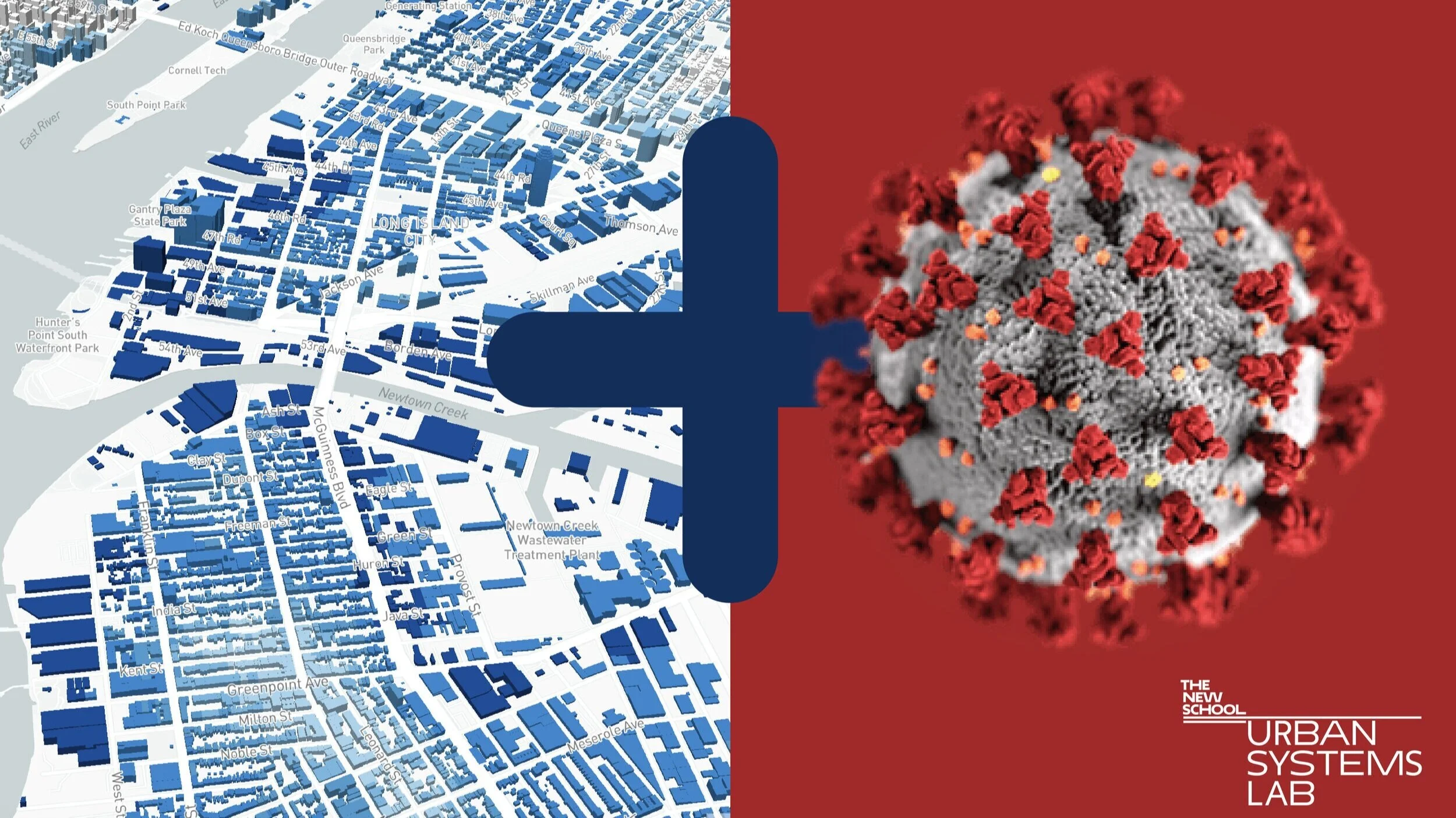
As part of this effort, the USL has launched stormwater.nyc a 3D data visualization mapping platform that integrates publically available data on stormwater resiliency in NYC, with population demographics, land use/cover data layers, location of critical infrastructure and greenspaces, and the New York Panel on Climate Change’s floodplain maps. To date, no other mapping platform has been developed that provides the ability to compare and contrast the potential social and infrastructural risk of future flooding scenarios in NYC. Over the coming months, the Lab will be adding in additional functionality that will allow toggling between layers to better interact with the scenarios and social and infrastructural layers, which we hope will provide a multi-hazard risk decision-support tool to improve resiliency prioritization. We will also be customizing this platform further and can also curate a series of waypoints that guide a reader through a narrative that highlights a neighborhood, e.g. one in each borough, where potential flood impact can be compared. 


In cities across the U.S., extreme precipitation is projected to increase in frequency and intensity due to climate change. Urban areas are especially vulnerable to extreme precipitation due to the presence of impervious surfaces that avoid water from infiltrating. Recent events like Tropical Storm Elsa make clear that this leads to higher amounts of stormwater that need to be managed by the city's sewer systems, which can lead to flooding and/or water quality issues. Our aim in launching stormwater.nyc is to create a central node for considering the interdependent and cascading risks that multiple climate hazards and threats have on NYC’s diverse communities and to enable informed and equitable decision-making, particularly for those most at-risk. 

Research Team:

  • Timon McPhearson, Director, Urban Systems Lab and Professor of Urban Ecology, The New School, timon.mcphearson@newschool.edu

  • Daniel Sauter, Associate Director, Urban Systems Lab and Associate Professor of Data Visualization The New School, sauter@newschool.edu

  • Claudia Tomateo, Research Fellow, The Urban Systems Lab, The New School,  tomateoc@newschool.edu

  • Veronica Olivotto,  PhD Fellow, The Urban Systems Lab, The New School, olivv722@newschool.edu 

Citation:

Herreros-Cantis, Pablo, Veronica Olivotto, Zbigniew Grabowski, and Timon McPhearson. 2020. “Shifting Landscapes of Coastal Flood Risk: Environmental (In)Justice of Urban Change, Sea Level Rise, and Differential Vulnerability in NYC.” Urban Transformations 2:9. https://doi.org/10.1186/s42854-020-00014-w

Project Theme

Urban Climate Resilience

Urban Resilience to Extreme Weather (UREx) Sustainability Research Network
Screen Shot 2020-10-06 at 2.50.54 PM.png

Project Team: Timon McPhearson, Ahmed Mustafa, Luis Ortiz, Katinka Wijsman, Bart Orr, Veronica Olivotto, Daniel Sauter, Claudia Tomateo, Chris Kennedy, Yaella Depietri, Elizabeth Cook, Rocio Carrero

USL is co-leading the Urban Resilience to Extremes Sustainability Research Network (UREx SRN), a five-year project funded through a $12 million grant from the National Science Foundation. The highly interdisciplinary UREx team includes scientists, students, planners, NGOs, industry, and other stakeholders in cities throughout the Americas. We are developing an innovative set of methods to assess how infrastructure can be more resilient, provide ecosystem services, and incorporate new technologies that strengthen socio-environmental wellbeing.

As part of the UREx project, USL is producing 3D visualizations that examine the equity implications of urban vulnerability. These interactive maps of nine cities integrate social, ecological, and technological data from a variety of sources. The map for New York City has played an important role in our collaboration with the Mayor's Office of Recovery & Resiliency and the Science and Resilience Institute at Jamaica Bay to reduce the city’s vulnerability to flooding.

project theme

Urban Climate Resilience

Future Earth Knowledge-Action Network
futurearth-tagline-blue-rgb-high-1024x467.jpg

Project Team: Timon McPhearson

Future Earth is an international research platform that helps accelerate transformations to a sustainable world. Its aim is to ensure that scientific understanding is generated in partnership with people throughout society to develop long-term solutions to environmental problems. USL has provided leadership as a member of the core development team, helping to launch the Urban Knowledge-Action Network (UKAN) and the Livable Urban Futures project.

Learn more

SMARTer Greener Cities
pexels-tom-fisk-2435296.jpg

Project Team: Erik Andersson, Timon McPhearson, Daniel Sauter

SMARTer Greener Cities aims to develop and test novel tools and processes for explicitly converging social, ecological, and technological approaches. The convergence of these approaches will promote resilient and equitable urban futures in Helsinki, Copenhagen, and Stockholm, and generate new opportunities for transformative change and increasing resilience to extreme events in other Nordic cities. The comprehensive integration of emerging science and practice connected to each of the three couplings (social-ecological (S-E), ecological-technological (E-T), and social-technological (S-T)) into a combined SETS framework is essential for the development of “smarter” (through systems) solutions for resilience and equity. We believe, despite the challenge of systems oriented research and practice, that we must cut across silos in disciplines, approaches, and knowledge systems by bringing technology, people, and nature together.

Learn More

PROJECT THemes

Urban Climate Resilience · Environmental Justice and Equity

Building Resilient Coastal Communities

Project Team: Timon McPhearson, Daniel Sauter, Claudia Tomateo

Building Resilient Coastal Cities through Smart and Connected Communities was a project to develop a data visualization and user interface design for web platform. This work involved mapping use cases, tools classification and social networks based on different stakeholders’ data from San Juan, Baltimore and Miami workshops. The product was represented in a series of interface workflow in form of storyboard (Screen designs), low fidelity wireframes and animated video mockups of platform usage. The tool is used as a “network of networks”, to help stakeholders map current projects and tools being used in the field and to discourage the duplication of efforts and co-production of knowledge.